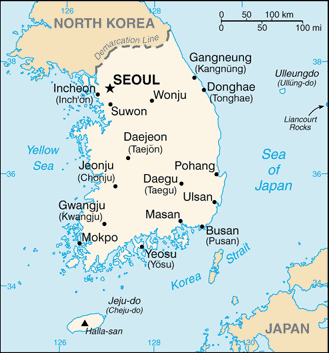
A Map of South Korea. A basic map with popular destination cities in English. Although the whole of Korea is a peninsula, technically South Korea is an island because of the north / south divide. China is located to the west and Japan is located to the east. South Korea is similar in size to Portugal.
Seoul is the capital and biggest city in Korea which is located in the northern region of South Korea and 40 km from the North Korean Border. Incheon the 4th biggest city is located west of Seoul and it is here that Incheon International Airport is located. In the south of Korea you can find Daegu, the 3rd largest city and Busan, the 2nd largest city. South of the peninsula you can see Jeju Island, a popular summer holiday destination for Koreans and Foreigners.
View below for an interactive map of South Korea.


